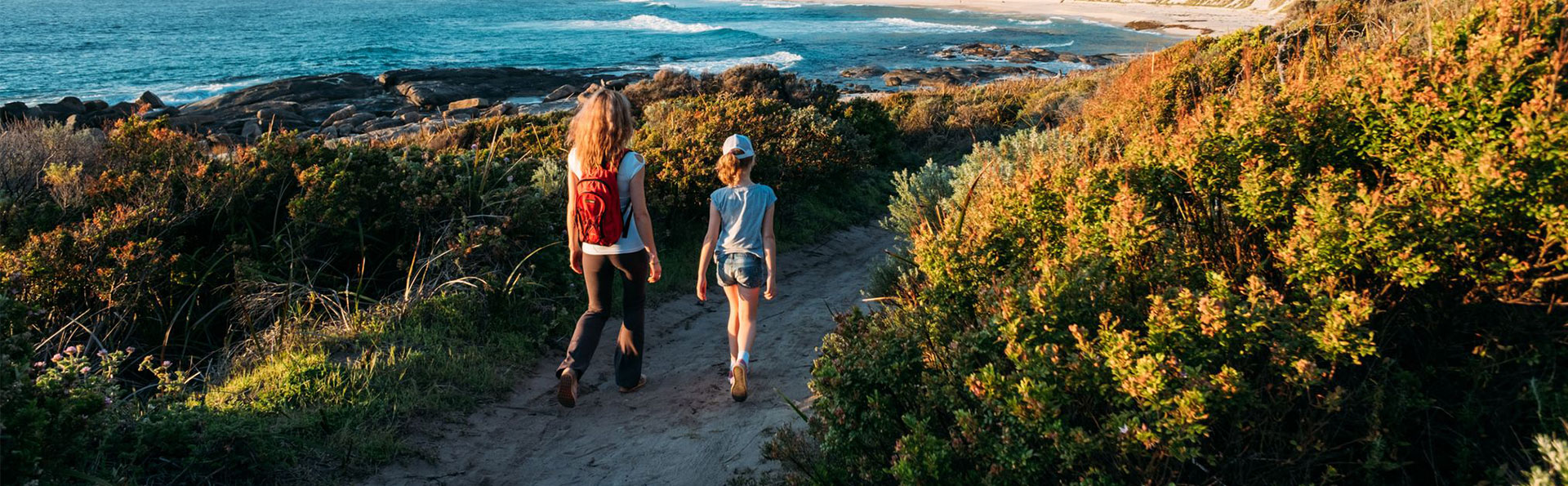
The Shire offers a diverse network of tracks and trails to explore on foot or by bicycle. From accessible paths and family-friendly bike routes to scenic hikes and challenging mountain bike trails, there’s something for all ages and abilities. These routes are a great way to connect with nature, stay active and experience the unique landscapes of the shire.
Wadandi Track
The Wadandi Track is currently 46 kms long across two sections: Busselton Jetty to Carbunup River and Cowaramup to Sebbes Road. As part of the State Government’s $165m Outdoor Adventure Tourism package, $17.5m has been allocated to complete the Wadandi Track between 2024-25 and 2027-28. The completion of the Wadandi Track will be delivered by the City of Busselton (CoB) and Shire of Augusta Margaret River (SoAMR) in partnership with Department of Transport and Major Infrastructure (DTMI). Once complete it will form a 109 km trail following the former railway line from Busselton to Flinders Bay in Augusta.
The funds will enable the final 63 km of track to be completed including new and refurbished bridges, various smaller water crossings and new sections of track as well as wayfinding, interpretation and activation. The track is named after the Wadandi people, the Traditional Owners of the land, and showcases their culture and history along the route, as well as scenic views of the coast, forests, farms and vineyards.
To find out more about this project visit the Wadandi Track Expansion | Building for Tomorrow webpage.
Margaret River trails
The Alfred Bussell Trail is a moderate walk and cycle trail that provides access from Margaret River town centre to the Wadandi Track and mountain bike trails located north of Carters Road.
Users may experience minor natural hazards such as short, steep sections, steps and uneven or slippery surfaces. A good level of fitness is recommended.
An interactive trail map is available online.
Minnie Keenan Trail is a linking trail between Rotary Park and the Wadandi Track (Carters Road). This moderate trail is only suitable for walkers.
Users may encounter minor natural hazards such as short, steep sections and uneven or slippery surfaces. A good level of fitness is recommended.
An interactive trail map is available online.
Accessed through the historic Old Settlement Precinct, Barrett Street Trail is a walk and cycle trail that provides access to Barrett Street Weir and the Bunnitj Biddi.
Barrett Street Trail is an easy well-defined trail with a firm surface. It is suitable for all levels of experience and fitness but may present difficulties for people with mobility impairments.
An interactive trail map is available online.
A moderate narrow walk trail that meanders along the Margaret River and Darch Brook between Rendall Close Weir and Riverslea residential area.
A good level of fitness is recommended as components of the trail consist of rocky/uneven surfaces.
An interactive trail map is available online.
A gentle well-defined walk and cycle trail following the alignment of a former timber tramway.
This trail is suitable for all levels of experience and fitness but may present difficulties for people with mobility impairments. Some trail sections may be poorly drained in winter.
An interactive trail map is available online.
Bunnitj Biddi is a walk and cycle trail that winds through forests of karri, marri, jarrah and blackbutt, with peppermint in the wetter areas.
It has a compacted surface with some gentle slopes, and steps in paths that lead to the water’s edge. It is suitable for all levels of experience and fitness but may present difficulties for people with mobility impairments.
An interactive trail map is available online.
Use this map to explore all seven trails in Margaret River.
Augusta trails
Whale Trail (2.7km return)
The Whale Trail follows the coastline from Flinders Bay to the Augusta Boat Harbour. There is also a continuous footpath that leads from the Blackwood River mouth near Colourpatch Café to Flinders Bay so experience can be extended. The whole trail is sealed and has a very flat gradient.
Cape Leeuwin Trail (3.4km)
The Leeuwin Trail currently extends from the Augusta Boat Harbour to Dead Finish. It has a firm surface and takes in magnificent views of the Southern Ocean.
Leeuwin Biddi Trail (3.3km)
Augusta’s newest section of the coastal trail connects Dead Finish to Cape Leeuwin Lighthouse with approximately 3km of scenic, accessible path for people to enjoy while walking, wheeling or riding.
This dual-use path is designed for all ages and abilities, with a mix of fine granite gravel and accessible concrete. It’s a safe, scenic route for anyone walking or jogging, riding a bike and families with prams, winding through some of Augusta’s most spectacular coastline.
Parking is available at Cape Leeuwin Lighthouse and opposite Waterwheel Road.
Other trails
Cape to Cape Track
The 125km Cape to Cape Track traverses the length of Leeuwin-Naturaliste National Park and overlooks the adjoining Ngari Capes Marine Park, alternating spectacular sweeping cliff-top views with stretches of pristine beach. This track is managed by the Department of Parks and Wildlife.
Visit Explore Parks WA for more information and Parks and Wildlife Service for Cape to Cape alerts and conditions.
Mountain bike trails
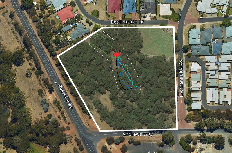
Brookfield Bike Park
Brookfield Bike Park is a free public facility for mountain biking and BMX, located 3km south of Margaret River at the corner of Bottlebrush Drive and Leschenaultia Avenue.
Nestled under the shady canopy of jarrah, marri and peppermint trees, our Brookfield Bike Park is a great place for mountain biking and BMX enthusiasts of all skill levels.
The park features three jump lines and a connecting trail loop, complete with jumps, rollers, table tops and berms. Whether you're a seasoned rider or just starting out, there's something here for everyone.
Getting there
The park is conveniently located approximately 3km south of the Margaret River town centre. Access is via the corner of Bottlebrush Drive and Leschenaultia Avenue, with a track next to the park’s picnic bench connecting you to the trails (see map below).
Important information
• Ride safely: Use the trails at your own risk and ride at your skill level. Safety gear, including a full-face helmet, gloves, knee and elbow pads, and enclosed shoes is strongly recommended.
• No motorised vehicles: Motorbikes and other motorised vehicles are prohibited in the reserve.
• Keep it clean: Please take your rubbish with you.
• Liability: The Shire of Augusta Margaret River accepts no liability for loss or damage to personal property or injury sustained as a result of using these trails.
A community effort
The Brookfield Mountain Bike Park was developed in response to the rise of unsanctioned trail building in local bushland reserves, which posed environmental and safety risks. In 2023, our Shire collaborated with local professional trail builders Magic Dirt Trailworx and local youth to transform these trails into a safe, approved area that meets Australian Mountain Bike Trail Safety Standards. The park officially opened 21 December 2024, following a successful trial period.
Ongoing maintenance and conservation
To ensure the safety and integrity of the trails, the park undergoes routine inspections. The surrounding bushland is being restored to improve its condition, habitat and biodiversity. This includes ongoing weed control and revegetation of degraded areas.
Get involved
The Shire is always looking for feedback and ideas to enhance the park. If you or your child have any comments or would like to participate in future initiatives, please register your interest by emailing [email protected].
For maintenance issues or other concerns, contact our Shire at 9780 5255 or [email protected].
More information and contact
More information and resources on trails, bushwalking and navigation is available though the following websites: